Trends and technology. You either embrace them, or you wait around to become a dinosaur that everybody secretly wants to avoid making conversation with.
Unfortunately, the construction industry spent a long time refusing to adopt technology, and it's been left down to brave pioneers like yourself to start dragging construction back into the 21st century.
The good news is you're not alone. And we've done some homework on three of the biggest technological trends you should be paying attention to in 2023.
The extra good news is that there's something to everyone's taste; whether drones and robots are your things or you love talking about mapping and topography, we've got something for you to get excited about.
Want to skip to a specific section?
3D point cloud technology is evolving
GIS and Mapping are becoming more popular
AI in the construction industry
1. 3D point cloud technology is evolving
Point cloud technology works by digitally scanning construction sites and collecting data that is then converted into 3D models and digital drawings. You can use that data to get a live view of the construction project and accurately compare plans against completed works.
The idea is pretty straightforward; a person (or a team goes) around with an on-site laser scanner, and then they scan the site and collect data. You can then use that data to build a "live" image of the site, which can later be converted into 3D models or CAD drawings.
Not only that, but when paired with a good coordinate system, you should be able to use your data to work out the northing, easting, and elevation of your project, helping to reduce potential errors and speed up construction.
Point cloud technology is also great for:
- Visual documentation
- Construction remodelling
- BIM
- Engineering designs
- Project animations
So far, so good, right?
The only problem is that the current process is very manual. And when you're working on a live project that changes regularly, the data and the drawings quickly become outdated.
Drones and construction
One approach that's quickly being adopted by the industry is the use of drones, AI, and robots (The latter is covered further down in this article).
Drones are becoming ever-present in the construction industry. According to The Manufacturer, there's been a monstrous 239% increase in the use of drones on construction projects over the past 12 months.
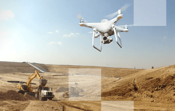
(Images Source: Propeller Aero)
How drones are used in construction
Drones are very quickly becoming a preferred method of building point clouds. They can quickly gather data from multiple angles of your site. Using a drone means having fewer people and equipment on the ground - reducing potential issues and incidents on your project.
Another reason many sites like to use drones is that they utilise both LiDAR sensors and Photgrammetary cameras. To over-simplify the way this works:
LiDAR Sensors send pulses of light which are reflected back off surface areas. This helps build up accurate visualisations of the site with laser-guided positioning.
Photogrammetry sensors work by taking high-definition photos of the site and building up a visual display of the area.
These two things together give you a very real picture of your site.
To learn more about LiDAR and Photogrammetry, check out this article by Heliguy.
Where to start with drone scanning
Large construction sites are getting tons of use from drone scanning: photogrammetry, data collection, and topography, to name a few.
But where do you begin if you're looking to start implementing drones on your project? A wide variety of drone scanning solutions are available to the construction industry, and it can be a difficult field to navigate. One particularly popular solution is Propeller Aero.
Propeller offers drones for multiple construction use cases and says they "developed a survey data collection, processing, and analysis formula that's highly accurate and sophisticated enough for survey teams, and easy enough for field crews."
If we were in the market for drone scanning solutions, that's where we'd start.
2. GIS and Mapping are becoming more popular
Site mapping tools and Geographic Information Systems, such as ArcGIS, continue to boom in popularity. And the rest of the industry is responding.
In a 2020 study by Business Wire, over 40% of contractors were found to be using GIS on over half of their projects. And that adoption continues is expected to continue growing in 2023.
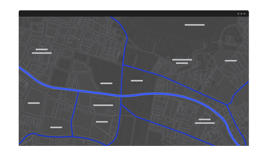
(Image of ArcGIS Make Maps feature - Source: Esri)
What is GIS mapping software used for?
Geographical Information Systems (GIS) help you capture data that can be easily stored, managed and converted into visual aids, such as maps.
Thanks to how this data is captured, these visual aids can be tied to specific coordinates and locations in space and time; giving you a virtual view of your project that correlates to your project in the real world.
What does this mean for your project?
It means you'll have access to real-world, real-time, layered scans of your project (and surrounding areas) that are tied to the actual coordinates of your site.
That's an extremely powerful tool to have access to when planning different stages of your project. And it's why so many projects are adopting the use of GIS in their workflow.
Why use GIS mapping software?
GIS mapping software, like ArcGIS, helps support project planning and analysis by providing a real-world overview of your site and the surrounding areas. With this kind of data, you can better visualise your project, helping you to create more efficient plans and minimise potential issues or delays.
According to the same study Business Wire study mentioned previously, over 88% of all GIS users report to have seen "Important Improvements" when using GIS mapping on their project.
The kinds of improvements mentioned in the study include things like: better processes and outputs, reduced risk, and more sustainable performance on their project.
Potential use cases for GIS include:
- Data Management
- Improved site safety
- Better communication
- Collaboration with third parties
GIS software can also help provide visual projections of your construction project, blueprints, and outlines of the required workspace.
This kind of data is a valuable aid throughout the planning process, reducing clashes and logistical errors and highlighting potential disruptions that might impact third parties, such as utilities companies.
Getting started with GIS
As with Point Cloud software, a variety of tools are available on the market, and each provides slightly different services under different names and guises.
One tool we'd recommend you check out is ArcGIS from ESRI.
We like this tool so much that in 2022 we launched ArcGIS integration with Aphex. If you're on our Pro+ or Enterprise plan, meaning you can view your Apex project and plans inside of ArcGIS and vice versa.

3. AI in the construction industry
Over the past few years, AI (artificial intelligence) has been taking the world by storm. From self-driving cars to writing tools and house-building robots (we'll move on to that shortly).
By 2028 the global market for AI is expected to reach north of $640 Billion US dollars. And with over 61% of employees saying that AI could help improve their productivity, it's no wonder why.
With those kinds of numbers being projected, it's inevitable AI will soon be working its way onto your construction project - if it hasn't already.
Use of AI in construction
It's no secret that construction tends to walk a tight line. Global demand is expected to keep rising, but the industry suffers from high risks and low-profit margins, leaving little room for error.
AI is looking to help you tackle both of those issues.
As AI continues to bleed into the outer edges of construction, first movers are already benefiting from things like streamlined data analysis, surveillance, drones, and robots. These are all things that, when put to good use and managed well, help lead to faster production, better profits, and fewer incidents.
That's good news for you, your project, and your contractor.
Below, you'll find just a few of the most exciting use cases for AI in construction right now.
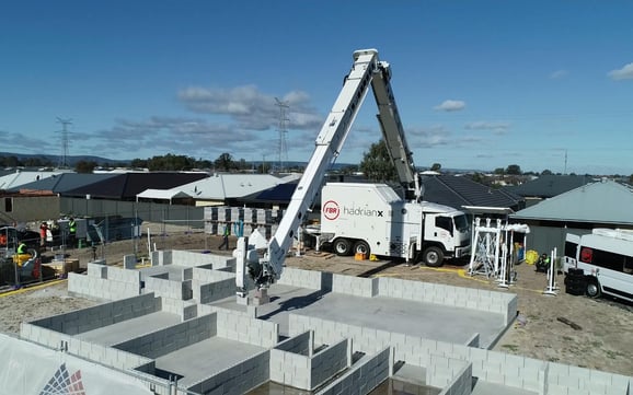
House Building Robots
Well, kind of.
Hadrian X is an incredible machine capable of laying blocks and building structures based on 3D models. According to the team at FDR, this dramatically reduces waste and helps to improve site safety.
"Hadrian X® is the world's first mobile robotic block laying machine and system, capable of safely working outdoors in uncontrolled environments with speed and accuracy." (FDR)
AI in Quality and Progress
There are a wide variety of companies looking to help streamline data analysis, reporting and communication software for the construction industry. One such company is Scaled Robotics.
Their AI enables workflow software to help you manage your site data in three steps:
- Capture work site data with terrestrial scanners or laser devices.
- Upload your data, then use AI and Machine learning to quickly run through thousands of elements.
- Deliver the information back to the user in a simple, easy-to-use interface.
Pretty cool.
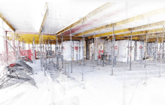
(Image of Scaled Robotics point cloud data - Source: GIM)
AI in construction Scheduling
The potential for AI is crazy! With new advancements seemingly being launched daily. One cool thing we've been playing with at Aphex is the possibility of using AI to aid you in construction scheduling.
AI change the way schedules are built by auto-populating suggestions when creating your short-term plans. Below is an example that our COO Jason Lancini shared on his LinkedIn page.
It's important to note that we've purely been playing with this for the sake of fun and experimentation. But you never know what the future may hold.
Conclusion
Times are changing. Construction is a high-risk, low-margin industry that severely underutilises modern-day technology. Fortunately, thanks to changemakers and forward-thinkers like you, that doesn't need to be the case for much longer.
Although there are many emerging trends in the industry, the growth of artificial intelligence, 3D point cloud technology, and GIS mapping are among so of the most exciting and beneficial.
If you’re looking for specific tools to check out, then we'd start with these:
PS. we know you're one of the good ones because you just read an article about emerging trends 😉